





















KILIA.
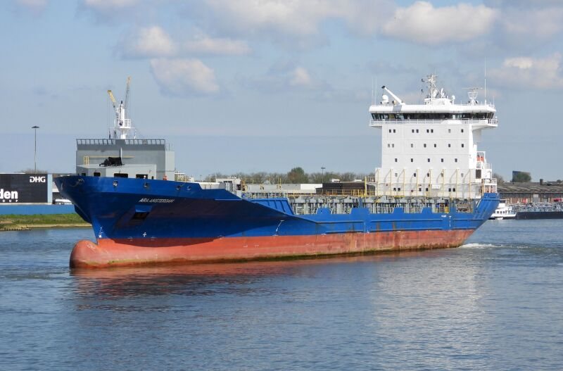
KILIA is a container ship with IMO number 9412517, sailing in the schedules of CMA CGM. Below: key figures, the carriers that sell space on the ship, its scheduled port calls and the destinations it reported on AIS. For the live position open the ship in Navo vessel tracking.
About KILIA
KILIA (IMO 9412517) is a container ship, 1,154 TEU, 157.69 m long, built in 2010 and flying the flag of Portugal. It is listed in the sailing schedules of CMA CGM. On AIS it broadcasts as MMSI 255806313 with call sign CQAY7. Its last position in the Navo AIS registry was 53.51° N, 4.80° E on 12 Nov 2026, reporting destination NLRTM.
Destinations reported on AIS
What the crew typed into the ship's AIS transponder, newest first, with the draught reported at the time. Free text, so it can be out of date.
| Reported | Destination | Draught | Load |
|---|---|---|---|
| 11 Nov 2026 | NLRTM Rotterdam | 8.5 m | laden |
| 11 Nov 2026 | NLRTM > DEHAM Hamburg | 8.5 m | laden |
| 11 Nov 2026 | NLRTM Rotterdam | 8.8 m | laden |
| 11 Nov 2026 | DEHAM Hamburg | 8.8 m | laden |
| 11 Nov 2026 | DEHAM"G | 8.8 m | laden |
| 11 Nov 2026 | DEHAM Hamburg | 8.8 m | laden |
| 11 Nov 2026 | DEHAM ELBE E3 P\S | 8.8 m | laden |
| 9 Nov 2026 | DEHAM Hamburg | 8.8 m | laden |
FAQ
- What is the IMO number of KILIA?
- The IMO number of KILIA is 9412517. Its MMSI is 255806313.
- Which carrier operates KILIA?
- KILIA appears in the sailing schedules of CMA CGM.
- What is the capacity of KILIA?
- 1,154 TEU.
- Where is KILIA now?
- The last AIS position on record is 53.51° N, 4.80° E on 12 Nov 2026. Open the ship in Navo vessel tracking for the live position.
- Operators and port calls come from the carriers' sailing schedules; MMSI, call sign, draught, destination and positions from AIS (ITU-R M.1371). Data as of 12 Nov 2026.
- More ships in the Vessel Library; ship classes in Vessel Types.