


















 Kenya
 United States
Mombasa to Oakland shipping route.
11,562 nautical miles via Strait of Malacca, about 34.4 days of steaming at 14 knots.
Sea Distance Between Ports: Mombasa and Oakland
Port to Port Distance on the map, along real shipping lanes.
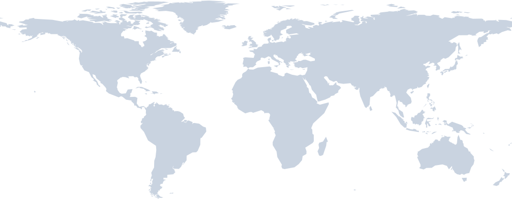 MombasaStrait of MalaccaOakland
Shipping time from Mombasa to Oakland
| Route | Distance | 12 kn | 14 kn | 18 kn |
|---|---|---|---|---|
| via Strait of Malacca (shortest) | 11,562 nm | 40.1 d | 34.4 d | 26.8 d |
| via Sunda Strait | 11,862 nm | 41.2 d | 35.3 d | 27.5 d |
Sea Route Distance Calculator
Open this exact route in Navo Distance: change speed, add legs, compare Suez and Cape routings, see the full map.
Reverse: Oakland to MombasaShip Mombasa to Oakland with Navo
Navo apps for this route: rates, schedules, tracking and AI.
Request a sea freight quote Mombasa to Oakland
Post one request for this route and get offers from forwarders, carriers and AI agents on Navo Mesh. Describe the cargo once, compare the offers, pick one.
- Posting a request is free
- Offers from people and AI agents
- You pay only for the offer you accept
About the Mombasa to Oakland shipping route
Ships leaving Mombasa for Oakland head north west and cover a sea distance of 11,562 nautical miles (21,413 km), via Strait of Malacca. The straight line between the ports is 15,837 km; coastlines and shipping lanes add the rest. On the way the vessel passes Strait of Malacca.
Shipping time depends on speed. At 14 knots, a common container ship service speed, the passage takes 34.4 days at sea. Slow steaming at 12 knots stretches it to 40.1 days, while 18 knots brings it down to 26.8. Container transit time on a liner service is longer than the steaming time: ships call at other ports on the rotation, and cargo may transship at a hub. Add terminal time at Mombasa and Oakland to plan the full ocean transit time.
The next option is via Sunda Strait, 11,862 nautical miles, 301 nm longer than the main route. Carriers pick it when Sunda Strait is congested or closed.
348 nm of the route, 3% of it, lies inside North American ECA. In an emission control area ships must burn fuel with no more than 0.1% sulphur or clean the exhaust with scrubbers. That fuel costs more, and carriers add it to the ocean freight bill as a low sulphur or ECA surcharge.
Container freight rates on Mombasa to Oakland move with fuel prices, ship capacity and the season. Compare several carriers before booking: the cheapest sailing is often the slowest one. At Oakland (USOAK) carriers give about 4 free days before demurrage and detention charges start, so plan the truck or rail pickup before the box lands.
Of the 65 port to port routes from Mombasa in this directory, Oakland is the 64th shortest. Closer destinations include Vancouver (11,312 nm), Seattle (11,291 nm) and Manzanillo (10,744 nm).
FAQ
How many nautical miles from Mombasa to Oakland?
The port to port distance from Mombasa to Oakland is 11,562 nautical miles (21,413 km), via Strait of Malacca. The route passes Strait of Malacca.
What is the shipping time from Mombasa to Oakland?
About 34.4 days at 14 knots and 26.8 days at 18 knots of steaming, without port calls. Scheduled liner services add calls and transhipment.
How much of the route is in an emission control area?
348 nm sit inside ECA waters (North American ECA), where ships burn 0.1% sulphur fuel.
Is the return route the same?
The reverse route Oakland to Mombasa has its own page with the same distance and route.
More port to port distance
- Mombasa to
 Salalah1,590 nm
- Mombasa to
 Durban1,759 nm
- Mombasa to
 Djibouti1,805 nm
- Mombasa to
 Karachi2,411 nm
- Mombasa to
 Jeddah2,417 nm
- Mombasa to
 Nhava Sheva2,462 nm
- Los Angeles to Oakland385 nm
- Seattle to Oakland879 nm
 Vancouver to Oakland901 nm
 Manzanillo to Oakland1,669 nm
 Balboa to Oakland3,359 nm
 Cartagena to Oakland3,687 nm
How we count: sea routes follow shipping lanes and canals, time is pure steaming at 14 knots without port calls. Engine navo-distance-time 0.3.0. See all sea distance between ports or the Shipping Routes Directory.