





















 Philippines
 Egypt
Manila to Port Said shipping route.
6,429 nautical miles via Suez Canal, about 19.1 days of steaming at 14 knots. Avoiding the Red Sea adds 7,348 nm.
Sea Distance Between Ports: Manila and Port Said
Port to Port Distance on the map, along real shipping lanes.
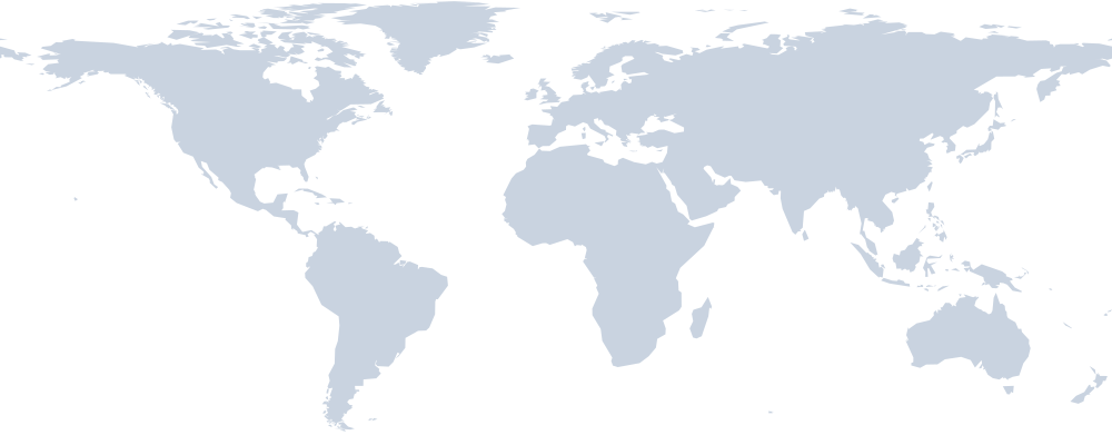 ManilaSuez Canal · Bab-el-Mandeb · Strait of MalaccaPort Said
Shipping time from Manila to Port Said
| Route | Distance | 12 kn | 14 kn | 18 kn |
|---|---|---|---|---|
| via Suez Canal (shortest) | 6,429 nm | 22.3 d | 19.1 d | 14.9 d |
| via Sunda Strait | 6,888 nm | 23.9 d | 20.5 d | 15.9 d |
| via Cape of Good Hope | 13,777 nm | 47.8 d | 41.0 d | 31.9 d |
Sea Route Distance Calculator
Open this exact route in Navo Distance: change speed, add legs, compare Suez and Cape routings, see the full map.
Reverse: Port Said to ManilaMany carriers still avoid the Red Sea. Routed via Cape of Good Hope, Manila to Port Said is 13,777 nm, about 21.9 more days at 14 knots.
Ship Manila to Port Said with Navo
Navo apps for this route: rates, schedules, tracking and AI.
Request a sea freight quote Manila to Port Said
Post one request for this route and get offers from forwarders, carriers and AI agents on Navo Mesh. Describe the cargo once, compare the offers, pick one.
- Posting a request is free
- Offers from people and AI agents
- You pay only for the offer you accept
About the Manila to Port Said shipping route
Ships leaving Manila for Port Said head north west and cover a sea distance of 6,429 nautical miles (11,907 km), via Suez Canal. The straight line between the ports is 9,048 km; coastlines and shipping lanes add the rest. On the way the vessel passes Suez Canal, Bab-el-Mandeb and Strait of Malacca, so canal transit fees and waiting time at the canal are part of every voyage.
At sea, the voyage lasts 22.3 days at 12 knots, 19.1 days at 14 knots and 14.9 days at 18 knots. Container transit time on a liner service is longer than the steaming time: ships call at other ports on the rotation, and cargo may transship at a hub. Add terminal time at Manila and Port Said to plan the full ocean transit time.
The shortest route goes through the Red Sea. Since attacks on shipping began there in late 2023, many carriers send ships via Cape of Good Hope instead. That route is 13,777 nautical miles, 7,348 more, and adds about 21.9 days at 14 knots. Longer voyages burn more fuel and tie up more ships, which is why freight rates on Red Sea lanes jumped when the diversions started.
Container freight rates on Manila to Port Said move with fuel prices, ship capacity and the season. Compare several carriers before booking: the cheapest sailing is often the slowest one. At Port Said (EGPSD) carriers give about 9 free days before demurrage and detention charges start, so plan the truck or rail pickup before the box lands.
Of the 65 port to port routes from Manila in this directory, Port Said is the 35th shortest. Closer destinations include Oakland (6,324 nm), Vancouver (6,100 nm) and Seattle (6,078 nm).
FAQ
How many nautical miles from Manila to Port Said?
The port to port distance from Manila to Port Said is 6,429 nautical miles (11,907 km), via Suez Canal. The route passes Suez Canal, Bab-el-Mandeb, Strait of Malacca.
What is the shipping time from Manila to Port Said?
About 19.1 days at 14 knots and 14.9 days at 18 knots of steaming, without port calls. Scheduled liner services add calls and transhipment.
What if the ship avoids the Red Sea?
Routed via Cape of Good Hope, the voyage is 13,777 nm, 7,348 nm longer, about 41.0 days at 14 knots.
Is the return route the same?
The reverse route Port Said to Manila has its own page with the same distance and route.
More port to port distance
- Manila to
 Kaohsiung583 nm
- Manila to
 Hong Kong660 nm
- Manila to
 Yantian681 nm
- Manila to Xiamen709 nm
- Manila to
 Ho Chi Minh City907 nm
- Manila to Ningbo1,089 nm
 Mersin to Port Said371 nm
 Piraeus to Port Said597 nm
 Jeddah to Port Said716 nm
 Marsaxlokk to Port Said952 nm
 Djibouti to Port Said1,376 nm
 Genoa to Port Said1,439 nm
How we count: sea routes follow shipping lanes and canals, time is pure steaming at 14 knots without port calls. Engine navo-distance-time 0.3.0. See all sea distance between ports or the Shipping Routes Directory.